
The Met Department has predicted light to moderate rainfall across parts of West Bengal, Andhra Pradesh and Odisha with the probability of the severe cyclonic storm 'Asani' recurving.

The very severe cyclonic storm 'Biparjoy' intensified into an 'extremely severe cyclonic storm' and is likely to cross Saurashtra-Kutch and adjoining Pakistan coasts around the afternoon of June 15 as a 'very severe cyclonic storm (VSCS)', the India Meteorological Department said on Sunday.

Green think tank Centre for Science and Environment (CSE) said the ongoing smog episode is a public health emergency.

This is the third time this season, after December 8 and January 1, that visibility has dropped to zero metres in the city.

Heavy downpour continued in various parts of Gujarat on Tuesday and six people died in rain-related incidents in the last 24 hours, raising the toll to 69 since June 1, officials said.
The mean minimum temperature for November was 9.6 degree Celsius in 1938; nine degree Celsius in 1931 and 8.9 degree Celsius in 1930, according to IMD data. Normally, the mean minimum temperature for the month of November is 12.9 degree Celsius.

Data released by the IMD on Thursday showed that the mean minimum temperature (MMT) this December was 7.1 degrees Celsius.

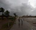
The cyclone is expected to make landfall on Thursday evening as a 'very severe cyclonic storm' with maximum wind speed reaching up to 150 kilometres per hour, the India Meteorological Department (IMD) said.

Floodwaters of the overflowing Yamuna reached the entrance of the Supreme Court in Central Delhi on Friday as the regulator of the Delhi irrigation and flood control department at Indraprastha suffered damage on Thursday evening.

Three national highways in Kutch, Navsari and Dang districts were blocked due to damage caused by rains. Fifty one state highways and over 400 panchayat roads have also been damaged, state Disaster Management Minister Rajendra Trivedi told reporters.

The state government has begun preparations to deal with the fallout of the cyclone as it will bring very strong wind and heavy rainfall in the region, officials said.
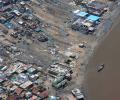
As many as 45 people have been killed due to cyclone Tauktae across 12 districts of Gujarat, officials.

A strong 6.8 magnitude earthquake with the epicentre in Afghanistan shook Pakistan, killing at least 12 people and injuring nearly 250 others in both the countries, authorities said on Wednesday.

Several global models are predicting El Nio to appear around the second half of the year, which are the crucial rain-bearing months.

According to an IMD forecast issued on Thursday, a heatwave spell will persist over northwest and central India during the next five days and over east India during the next three days.

As per the India Meteorological Department many districts in Maharashtra recorded maximum temperatures of 40 degree Celsius or above in the last two days.

Isolated heavy rainfall is also very likely over north Konkan region during the same period, it said.

Experts said unfavourable meteorological conditions -- calm winds and low temperatures -- and smoke from farm fires in neighbouring states led to a dense layer of haze as the air quality index entered the "severe" zone.

Data spanning the years 1951 to 2014 show that temperature and pressure conditions at specific locations in the Arctic region during the pre-monsoon period correlate with the Indian summer monsoon rainfall, points out Charu Bahri.

'Due to severe rains and heavy cross winds, arrivals at #AAI Chennai Airport will remain suspended from 1315 hrs to 1800 hrs, today. Departures will continue. The decision has been taken considering the safety aspect of passengers and severity of wind,' the Chennai Airport tweeted.

Cyclone Tauktae weakened into a 'depression' and lay centred over south Rajasthan and adjoining Gujarat region on Wednesday morning, the India Meteorological Department said.

While there was a brief respite from the incessant downpour on Tuesday, collaborative efforts from the defence, national, and state disaster response forces took the lead in executing rescue and relief operations.
The IMD has warned of squally winds speed reaching 45-55 kmph gusting to 65 kmph likely to commence along and off Odisha and north coastal Andhra Pradesh coasts from October 27 onwards.

'Yaas' is likely to cross the Odisha-West Bengal coasts between Paradip and Sagar Islands around noon on May 26 as a very severe cyclonic storm with wind speeds of 155-165 kmph, Kolkata's Regional Meteorological Centre Deputy Director Sanjib Bandopadhyay said.

The Ayanagar weather station recorded 122.8 mm between 8.30 am on Wednesday and 8.30 am on Thursday, which was 11 times the normal rainfall.

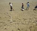
About 4.41 lakh rural habitations are facing drinking water scarcity and the government is closely monitoring the drought situation on a daily basis in 10 states, Agriculture Minister Radha Mohan Singh said on Saturday.

The water level at the Old Railway Bridge crossed the 208-metre mark Wednesday night and rose to 208.48 metres by 8 am on Thursday. It is expected to rise further, according to the Central Water Commission, which has termed it an "extreme situation".

The situation could worsen if weather predictions of more rain in the capital and upper catchment areas come true.

The India Meteorological Department, which had issued a red colour-coded alert for north India for May 25-26 when the prevailing heatwave conditions are expected to peak, said dust and thunderstorms are likely to bring some relief on May 29-30.

The area under paddy - the biggest foodgrain during the kharif season - was almost 13 per cent lower in the week ended August 5 as compared to the same period last year despite a slight pick-up in rains in the main growing regions, triggering fears of a 10-12 million-tonne drop in final output. Sources said with the peak sowing season for paddy almost coming to an end in the big-growing states, any uptick in coverage from here onwards may not give the desired yields. With 30 per cent of normal average area in which paddy is grown every year remaining unsown till early August, there is a limited chance of a big uptick in output, trade and market sources said.

Prime Minister Narendra Modi on Tuesday announced Rs 1,000 crore as interim relief for the cyclone-hit Andhra Pradesh as he undertook a survey of the worst-affected city.

Just two days after recording 811.6 mm of rainfall in a day, Cherrapunji in Meghalaya received a bountiful 972 mm of precipitation in 24 hours ending 8.30 am on Friday, the highest in June since 1995 and the third highest in 122 years, the India Meteorological Department (IMD) said.

The city also recorded a maximum temperature of 23.8 degrees Celsius, 16 notches below normal and the lowest in the month of May since 1951, the IMD said.

In a statement, it said 198 properties in the state were partially damaged and 30 houses completely destroyed in the rains from July 31 to till date.
Rain deficiency in eastern and western Uttar Pradesh, Bihar, Jharkhand, Gangetic West Bengal, Assam and Meghalaya is 20-46 per cent less than normal as of June 17.
Incessant rains unleashed more death and destruction on Monday in parts of north India, with 37 people killed in landslides and other rain-related incidents in the last two days even as the Army and NDRF teams stepped in to intensify the relief and rescue operations.

The weatherman said when 'Amphan' makes the landfall between West Bengal's Digha, some 180 km from Kolkata, and Hatiya island in Bangladesh on Wednesday afternoon or evening, it will pack sustained wind speed of 155 to 165 kmph, gusting at 185 kmph. The gale-force wind, blowing at a speed of 240 to 250 kmph and gusting to 275 kmph at one point, had lost intensity and was moving at a speed of 200 to 210 kmph, gusting to 230 kmph on Tuesday evening.

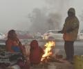
The minimum temperature settled at 2.6 degree Celsius at the Safdarjung observatory, four notches below the season's average, and humidity was 100 per cent. The visibility recorded by the Safdarjung and Palam observatories stood at zero metres at 8.30 am. It was recorded at 100 metres at Safdarjung and zero at Palam at 5.30 am.

According to the Graded Response Action Plan (GRAP), the air quality is considered to be in the emergency category if the PM2.5 and PM10 levels continue to be above 300 micrograms per cubic metre and 500 micrograms per cubic metre respectively for 48 hours or more.

The total rainfall till now is not only deficient, but is also erratic in terms of both geographical spread and timings.